But many of the country’s most famous adventure spots sit far beyond the reach of a cell tower, so preparation is essential. Most of us head out assuming that if something goes wrong, we can call, text or check a map. At some of these places, that simply isn’t true.
So where in America are thrill-seekers most likely to be on their own? The Holafly research team measured mobile coverage at 97 of the country’s best-known climbing areas, whitewater runs, peaks, backcountry ski spots, caves, and BASE jumping and skydiving sites. Using FCC coverage data for AT&T, T-Mobile and Verizon, the team identified connectivity gaps to set realistic expectations and help travelers prepare properly, especially for trips to remote areas where mobile coverage may be limited or nonexistent.
Key Findings
- Nearly half of America’s most famous adventure spots (48 of 97) have at least one location where none of the three major carriers reports any coverage.
- Idaho’s Selway River tops the ranking as the most disconnected adventure spot in the country, with a Dead Zone Score of 93.9/100. At its launch point, the nearest signal from any carrier is 18.2 miles away.
- On the summit of Denali, the nearest signal is 7.4 miles away and the nearest hospital with an emergency room is 118 miles away.
- Idaho is home to three of the top five most disconnected spots, all of them whitewater rivers, and six of the top 20, more than any other state.
- Your network can make all the difference. On Idaho’s Borah Peak, AT&T and T-Mobile report coverage within 0.15 miles of the summit, while Verizon’s nearest coverage is 20.7 miles away.
America’s Most Disconnected Adventure Spots
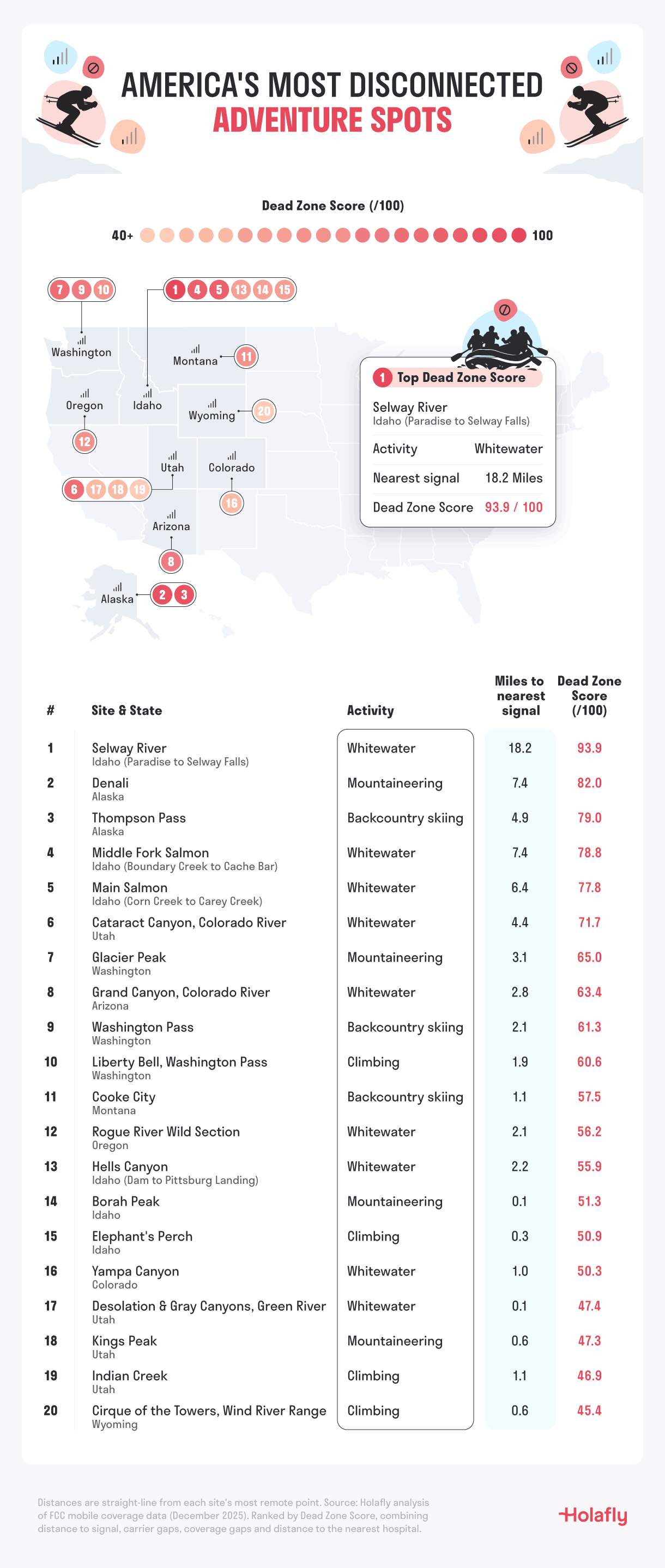
1. Selway River, Idaho - 93.9/100
The Selway doesn’t just feel remote. It is. One of the most sought-after river trips in the country, this Class IV run cuts through the heart of the Selway-Bitterroot Wilderness, and it tops our index by a wide margin. At the Paradise launch, the nearest reported coverage from any carrier is 18.2 miles away: 18.2 miles for AT&T, 18.9 miles for Verizon and 20.1 miles for T-Mobile.
Even at the end of the run, near Selway Falls, the nearest signal is more than two miles away. Help is a long way off too. The nearest hospital is around 39 miles from the launch and 43 miles from the take-out as the crow flies, and much farther by road.
2. Denali, Alaska - 82.0/100
At 20,310 feet, Denali is the highest peak in North America and one of the most demanding climbs on the continent. From its summit, the nearest reported coverage is 7.4 miles away on Verizon and 11.2 miles away on AT&T. T-Mobile does not report any coverage of its own in Alaska.
Denali is also the farthest site in our index from emergency care. The nearest hospital with an emergency department, Mat-Su Regional Medical Center in Palmer, is 118 miles away in a straight line.
3. Thompson Pass, Alaska - 79.0/100
Thompson Pass, near Valdez, is one of the snowiest places in Alaska and a magnet for backcountry skiers. The nearest reported coverage is 4.9 miles away, on AT&T. Verizon reports no coverage within 40 miles, and T-Mobile does not report coverage of its own in Alaska.
The nearest hospital, in Valdez, is around 20 miles away. That gap between networks is why Thompson Pass ranks third overall, ahead of sites where the nearest signal is farther away.
4. Middle Fork of the Salmon, Idaho - 78.8/100
The Middle Fork carves around 100 miles through the Frank Church-River of No Return Wilderness, the largest contiguous wilderness area in the Lower 48. None of the three points we measured along the river has coverage from any major carrier.
At the Boundary Creek launch, the nearest signal is 7.4 miles away. Deeper into the run, in Impassable Canyon, AT&T and Verizon users would be more than 14 miles from their nearest coverage. The closest hospital, in Salmon, is around 39 miles away.
5. Main Salmon, Idaho - 77.8/100
Known as the River of No Return, the Main Salmon lives up to its name. At the Carey Creek take-out, the nearest signal from any carrier is 6.4 miles away. At the Corn Creek launch, T-Mobile reports coverage 1.3 miles away, but AT&T users would need to go 15.1 miles and Verizon users 17.7 miles.
The Most Disconnected Spot For Each Activity
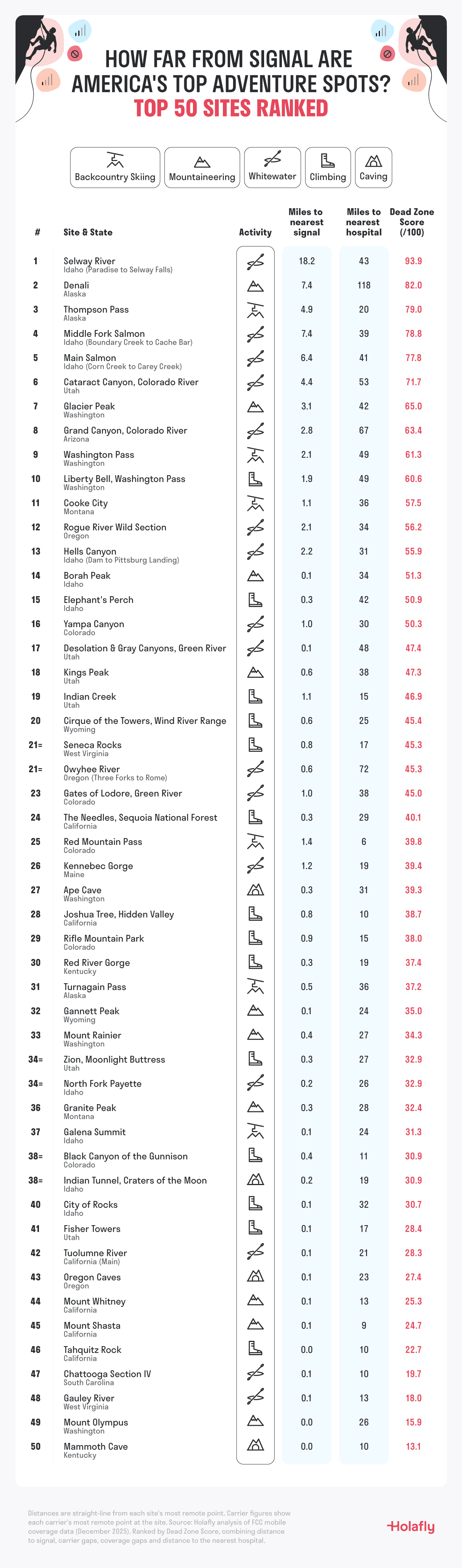
Whitewater: Selway River, Idaho. Rivers dominate the top of our index. Half of the ten most disconnected spots are whitewater runs, where canyon walls and wilderness keep cell towers far away. The Selway tops the list at 18.2 miles from the nearest signal.
Mountaineering: Denali, Alaska. North America’s highest peak is 7.4 miles from the nearest signal and 118 miles from the nearest emergency hospital. In the Lower 48, Washington’s Glacier Peak is the most disconnected summit, at 3.1 miles. If you’re planning a mountain trip further afield, see our ranking of the world’s top mountain escapes.
Backcountry skiing: Thompson Pass, Alaska. Skiers here are 4.9 miles from the nearest coverage, and only AT&T reports any signal within 40 miles. In the Lower 48, Washington Pass in the North Cascades is the most disconnected ski spot, at 2.1 miles.
Climbing: Liberty Bell, Washington. The granite spires above Washington Pass are the most disconnected climbing spot in our index. The nearest signal is 1.9 miles away, rising to 10.1 miles for Verizon users, and the nearest hospital is 49 miles away.
Why Your Network Matters
At some sites, your network decides whether you have signal. On Idaho’s Borah Peak, AT&T and T-Mobile both report coverage within 0.15 miles of the summit, but Verizon’s nearest coverage is 20.7 miles away.
Emergency 911 calls can connect over any network with a signal, but messaging, maps and location sharing usually rely on your own provider, so two climbers standing side by side can have very different options. It’s why Borah Peak ranks 14th in our index, despite two of the three networks reaching almost to the summit.
How to Stay Safe When You Head Off-Grid
Losing signal doesn’t have to mean losing your way. A little planning before you set out makes a real difference.
1- Check coverage for your network before you go
Coverage varies widely between carriers, as our findings show. The FCC National Broadband Map lets you check what your provider reports for any location, so you know where you’re likely to lose signal before you leave home.
2- Download offline maps and guides
Download maps, route descriptions and trail guides while you still have a connection. Most navigation apps let you save areas for offline use, which means your GPS will still show your position even when you have no signal.
3- Stay connected with a travel eSIM
Whether you’re hiking in remote national parks, driving through vast landscapes or exploring rural areas, access to more than one mobile network can be more than a convenience. It can be a lifesaver. That’s where a travel eSIM really comes into its own.
If one network has no signal, the eSIM automatically switches to another supported network that does. That can be the difference between staying connected and losing signal completely, giving you another chance to get online when you need help, want to check your route or need to contact emergency services.
4- Leave a trip plan with someone at home
Tell someone where you’re going, which route you’re taking and when you expect to be back. If something goes wrong somewhere with no coverage, this is often how rescuers know where to start looking.
5- Carry a satellite messenger or personal locator beacon
At the most remote spots in our index, a phone alone isn’t enough. A satellite messenger or personal locator beacon can send an SOS from places with no mobile coverage at all.
America’s wild places are some of the most spectacular on the planet, and part of their appeal is how far they take you from everyday life. But as our findings show, at many of them you’re further from help than you might think. Plan ahead, know where your signal ends, and you can enjoy them safely.
Methodology
To create our ranking, we analyzed 97 of America’s best-known adventure spots across six activities: climbing, whitewater, mountaineering, backcountry skiing, caving, and BASE jumping and skydiving. Each site was scored on four factors: distance to the nearest signal from any carrier, average distance to signal across AT&T, T-Mobile and Verizon, the share of measured points with no signal, and distance to the nearest hospital. Each factor was given a score out of 100, and the scores were combined into a Dead Zone Score out of 100, with the two signal factors weighted most heavily. River runs were measured at several points and scored on their most remote point.
Data sources: The FCC National Broadband Map was used to collect 4G and 5G coverage data for each carrier (as of December 31, 2025). Site locations were collected from Mountain Project, American Whitewater, the US Forest Service and the Bureau of Land Management, and distances to the nearest hospital were calculated using OpenStreetMap. Coverage reflects what carriers report to the FCC and may differ from real-world conditions.